Montana Outdoors

February 28, 2009

In search of a trail (2)

Yesterday my son and I tried again to find the lower end of the Fourteen Mile trail (USFS trail 1714), this time in 4 inches of new snow, and tasted a little success with the discovery of some old blaze marks on a tree a few hundred feet above the river. We lost it soon after because of the snow but I’m sure now that with the appropriate topo maps I will be able to locate it, although not until most of the snow has melted.

The following photo illustrates why I want so much to find the trail. It was taken from about three miles from the Jeep and a thousand feet above the river, and the top of the trail is still several miles and 3,500 feet further up the mountain. I have to think the views from the upper reaches will be worth the climb.

Our companions at this point were five huge Big Horn rams who were also looking out over the river. The trail is in the Patrick’s Knob Roadless Area of western Montana’s Coeur d’Alene Mountains and the country across the river is in the South Siegel Roadless Area.

South Siegel Roadless Area

June 29, 2008

The longest three mile trail in Montana (Part 4)

This will be the last post in this series: after all, how much can be said about a three mile trail?

The Clark Fork of the Columbia River flows in a northwesterly direction for about three hundred miles from its source in the Deerlodge National Forest at the Continental Divide near the town of Butte Montana then takes a sharp turn to the right and and flows for twenty one miles due east before it again turns toward the northwest. This short east – west section is referred to as the “Cutoff”, probably because it’s a shortcut from the Bitterroot Mountains on the west, through the Coeur d’Alene Mountains to the Cabinet Mountains on the east, and there is a road which follows the river, Montana Highway 135.

As you travel downstream through the Cutoff you travel through a deep canyon where, to the right is the high ground of the South Siegel – South Cutoff roadless area (13,473 acres) and the North Siegel roadless area (9,208 acres). To the left is the Patrick’s Knob – North Cutoff roadless area (16,969 acres). About half way through is the trail head for USFS trail 205 which runs almost due north for (the Forest Service says) three miles through the Patrick’s Knob area at one of it’s narrowest points, from the river at an elevation of about 2,500 feet to the high ridge at about 5,000 feet just west of Patrick’s Knob Peak . (After hiking the trail myself, I came to believe that the person who declared it to be three miles has never even seen the trail, much less hiked it.)

The following photos will, I hope, give the viewer a little of the flavor of this particular trail and the beauty of the roadless area it traverses and a glimpse of what it’s like to hike through true wild country. It is only one of many such trails in many roadless areas, all of which need our protection if they are to continue to exist.

The trailhead at Montana Highway 135

Trailhead for USFS trail 205

An early part of the trail, perhaps a half mile from the trailhead.

On trail 205

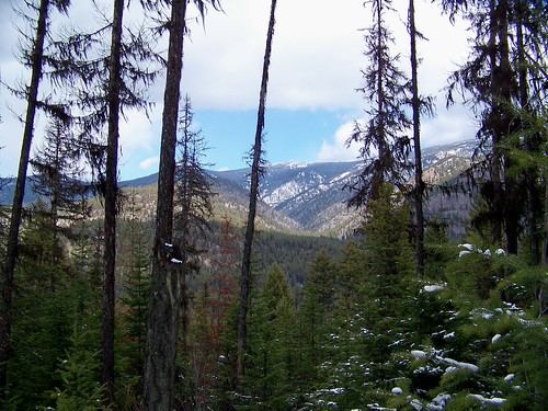
From about a mile up the trail facing east along the Cutoff with the North Siegel roadless area in the background,

From trail 205

and from the same spot, facing south with the South Siegel – South Cutoff roadless area in the background.

From trail 205

A section of the trail itself about three fourths of the way to the top (It’s a good idea to pay attention to the blaze marks through here),

Trail 205

and, from about the same place, a view back down to the Clark Fork and Highway 135.

From trail 205

At the top edge of the roadless area and the top end of the trail is, what else, a road. In this case it’s called The High Ridge Road and also the eastern trailhead of the CC Divide Trail, USFS trail 404.

High Ridge Road

From the high Ridge Road facing north, Baldy Mountain in the Baldy Mountain roadless area can be easily seen ten miles beyond the small town of Plains, Montana along the Clark Fork which at that point is again headed northwest.

Baldy Mountain from the CC Divide

The previous photos were taken on the ascent. I also took a few on the hike back down.

A quarter of a mile behind this rather obscure trail marker at the top end of the trail (with my pack hanging on it)

Trail marker for the top of trail 205

is this trail sign, the only one to be found on the entire trail.

Trail sign for trail 205

A mile or so from the top, where the trail takes a slight jog to the west is a nice view of the Bitterroot Mountains about thirty miles to the west,

Bitterroot Mountains from trail 205

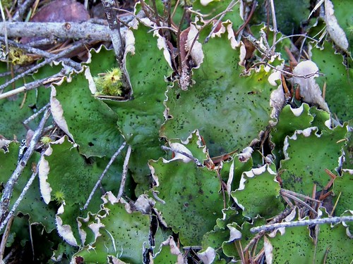
and in a place where the only relatively level part of the trail occurs is a nice section of open forest which I’ll bet is a favorite feeding area for the local ungulates (deer, elk, moose and Bighorn sheep).

Along the trail

Half way back down is this pretty view of the Cutoff and North Siegel beyond it,

From trail 205

and the trailhead at the bottom, after seven hours on this six(?) mile hike is a welcome sight.

Bottom trailhead for trail 205

April 3, 2008

April 2, Trail 223, the trail

When I first explored part of this trail back in January, it looked like it would provide a very scenic hike for about eight miles along the Clark Fork river while staying within the South Siegel – South Cutoff roadless area. Wednesday I hiked the first three miles and found it a little disappointing: I decided not to spend more time hiking further on that trail.

Trail 223 is a quite pleasant place for hiking, with beautiful wide stretches ambling between the trees, nearly all firs with a few pines sprinkled in among them and cedars in the bottoms of the small canyons which lead off into the high country,

Trail 223

stretches that had still had a fair amount of snow remaining,

Trail 223

and the canyons provide enough terrain relief to break up the monotony,

Trail 223

but both sides of the trail are forested to the extent that there are very few places where it is possible to get a good look at the surrounding country. I guess I’m spoiled and want to see the mountains and canyons in the distance and to be able to ascend to the high country and have the views that eagles have.

However, this hike did let me accomplish a secondary goal and that was to get a bit of a look into the south slope of the Patrick’s Knob – North Cutoff roadless area which is just across the river. In the next photo, taken through one of the gaps in the trees, the snow covered peak of Patrick’s Knob can be seen at about 4 miles away and five thousand feet above.

Patrick's Knob

From the high ridge that leads up to the peak there are two trails that lead down to the river. One (USFS trail 1714A) ambles off along the ridge to the right before it drops down and the top several miles should provide spectacular views of the entire area including the north slope of the South Sigel roadless area. Judging by the map it will be about nine miles from the peak to the river, including one mile of elevation change.

The second (USFS trail 215) is only about three miles long and descends abruptly from the left side of the peak almost directly down to the river. It will be a trail where you lace you boots up very tight and prepare for a ton of switchbacks on the way down!

I plan to hike both of these trails during the first part of the summer, probably late May or early June and photograph the trips. Besides the terrific views, there are a large number of Big Horn sheep who live in the area as well as black bear, cougar, deer, elk and moose.

The last photo provides a closer look at the peak and illustrates why it will be a couple more months before it will be possible to begin a hike from there.

Patrick's Knob

April 2, 2008

April 2, Trail 223, flora

The forecast for today was for snow showers in the morning, brief periods of sun and possible rain in the afternoon. As it turned out, there were no showers of either kind and the temperature while I was on the trail stayed in the 20’s. A great day for hiking!

Tomorrow I will post a few photos of the trail, but for now just a few of some interesting flora, including a type of lichen I have never seen before.

Near the beginning of US Forest Service trail 223 after it heads into the South Siegel – South Cutoff roadless area there is a nice stand of cedars, extending quite a distance along the Clark Fork river and up into the side canyons that trickle down from the high country. I rested my staff against the trunk of this one when I photographed it to provide some size perspective. The staff is 56 inches long.

Cedar

Along the trail there are many of these common but rather bright colored fungi. It is about 4 inches across.

Tree fungus

This lichen appeared to be part of the winter food supply for the plentiful white-tail deer in the area. What looks like leaves are 2 to 3 inches wide. There is a lot of it growing in the area and in fairly large patches. If I’m right that it is food for the deer, they are well supplied.

Lichen

I have not seen this particular lichen before today. The individual strands are about 2 inches long.

Lichen

January 13, 2008

U.S.F.S.trail # 223T, the beginning

Trail 223T appears to be a fairly easy and pleasant route to access at least the lower elevations of the South Siegel – South cutoff roadless area. I have just begun to explore this great looking trail and so far have just seen the first part of it. The first three photos were taken where it begins, at an elevation of 2560 feet along the Clark Fork river where Montana Highway 135 makes its only crossing of the river at the Fourteen Mile bridge. The high ground (6000 feet elevation) of the area can be seen at the skyline in the first one.

Clark Fork on the cutoff


Clark Fork on the cutoff


Clark Fork on the cutoff

It soon enters the forest and follows the course of the river upstream for 8 – 10 miles in the forest just above the river, staying just inside the lower (northern) boundary of the roadless area.

USFS trail #223

This is a beautiful piece of Lolo National forest consisting mostly of fir, pine and cedar with lush undergrowth and tiny seeps of water trickling down out of the high country above. The tracks on the log footbridge are those of deer and coyotes, both of whom are abundant here.

USFS trail # 223.

This section is a bit higher, 250 feet above the river where the trail climbs to get past the nearly vertical hillsides next to the river. The tracks in the photo are those of a cougar. I have not visited here before this winter, but I can imagine its summertime beauty!

USFS trail # 223

The following photos were taken from just off the trail as it winds through one of its higher sections. This is a heavily shaded section of trail and would be a wonderfully cool place for a leisurely hike during the mid-day heat of late summer.

The Clark Fork seen from trail 223.


The Clark Fork seen from trail 223

I plan to explore more of the trail in the next few days and will post more photos of what I encounter, but the trail conditions are not the best for hiking at the moment, with snow levels varying from a few inches to a foot: deep enough to make hiking difficult, but not deep enough for snowshoes. In such a pretty area though, and with no one else’s tracks anywhere around, I know it won’t be possible to stay away!

January 11, 2008

A new playground

Today was spent snooping around a brand new playground called Forest Service trail #223, most of which is within the South Siegel roadless area. Well, I had a pretty good idea it was there, but had never visited. It runs for 8 or 9 miles on the south side of the Clark Fork (to the left in this photo)

Clark Fork on the cutoff

where the river flows eastward for about 20 miles through the Coeur d’Alene mountains between the South Siegel roadless area and the Patrick’s Knob roadless area, a section called “the cutoff”.

On the trail, about a mile from where this photo was taken,

Clark Fork on the cutoff

beyond the river and over the hill, I missed a very, very big cougar by only a few seconds. As I stepped over the sharp crest of a steep slope there were skid marks on the trail ahead, much like those one would leave when stopping quickly on short skis, where he sensed my presence, slid to a halt and then sprang off the trail and down into a deep canyon. If only I had been a little more alert! Here’s what his track looked like beside my boot.

Cat track!

The prints of his pads can clearly be seen, but consider also the smooth shadow around the pads where the rest of his foot pressed into the snow. His foot was wider than mine! As I followed his track as far as I could, I was filled with a strong feeling that there are still some very wonderful things left in this world!

Older Posts »

Create a free website or blog at WordPress.com.