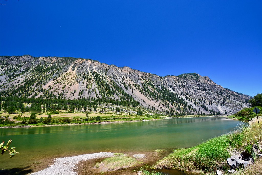
The Clark Fork River with the south slope of KooKooSint Ridge in the background. Finally, a picture of that slope that I like.
The Clark Fork River with the south slope of KooKooSint Ridge in the background. Finally, a picture of that slope that I like.
RSS feed for comments on this post. TrackBack URI
This site uses Akismet to reduce spam. Learn how your comment data is processed.

This river has so many beautiful twists and turns, and I’ve only seen the ones that cross under or flow beside the highway. I can imagine some of the inaccessible parts must be just idyllic.
LikeLiked by 1 person
Comment by wordsfromanneli — July 13, 2018 @ 7:41 pm
There’s not too much of it that isn’t accessible, but it’s very scenic most of its length. And pretty good fishing too.
LikeLiked by 1 person
Comment by montucky — July 13, 2018 @ 7:52 pm
I realized after I sent it that inaccessible isn’t the right word. I meant the parts that are not right by the highway for people like me who are just passing through. But yes, a beautiful river. I’d love to try fishing it just once.
LikeLiked by 1 person
Comment by wordsfromanneli — July 13, 2018 @ 7:54 pm
THe fishing can be good, and a lot of local people fish it, but you have to get to know the river to have good success. The time of day is important there, and just at dusk is the best time. Sometimes I “cheat” by going well up on the bank in the evening with binoculars and watch for big fish that are rising to natural surface food and then go drop a fly where they are rising. Works well!
LikeLiked by 1 person
Comment by montucky — July 13, 2018 @ 8:18 pm
Sounds like the Captain’s favourite tactic too
LikeLiked by 1 person
Comment by wordsfromanneli — July 13, 2018 @ 8:37 pm
I’m not surprised!
LikeLiked by 1 person
Comment by montucky — July 13, 2018 @ 10:08 pm
Wow–a commanding view unlike anything here in the Northeast.
LikeLiked by 1 person
Comment by lmachayes — July 13, 2018 @ 8:32 pm
The ridge across the river (beyond the crest) is about 15 miles long and several miles wide and the top a is beautiful un-touched forest of firs and pines. It is accessed only by trails, of which there are five; one from the west, one from the middle on its south side, one from the northwest and two from the east. I’ve hiked all but one and I did hike a couple of miles on that one only along the top of the ridge. It’s a beautiful piece of wild country!
LikeLike
Comment by montucky — July 13, 2018 @ 9:52 pm
What a lovely scene – thanks for bringing it to us!
It must be a very slippery slope to have such little vegetation cover?
LikeLiked by 1 person
Comment by de Wets Wild — July 13, 2018 @ 8:52 pm
The slope is very steep, but Big Horn Sheep negotiate it in a few places. There are trails on the other sides that take you to the top. I hike there often.
LikeLiked by 1 person
Comment by montucky — July 13, 2018 @ 9:54 pm
Beautiful view, beautiful sky!
LikeLiked by 1 person
Comment by Candice — July 13, 2018 @ 8:53 pm
Fortunately, the sky in this area is still fairly clear. Fifty miles to the south there is quite a bit of smoke that has blown in from fires as far away as Colorado and Utah, with a little from a big fire in northern California.
LikeLiked by 1 person
Comment by montucky — July 13, 2018 @ 9:56 pm
I had a sudden vision of you there by the river’s edge, saying, “Here, fishie, fishie!” It’s a beautiful spot — and I can see why you’re pleased with the photo. It’s great to have some accessible spots, too. The back country’s gorgeous, but I suspect there are plenty of people unable to get back there who are delighted to have places like this.
LikeLiked by 1 person
Comment by shoreacres — July 13, 2018 @ 9:23 pm
There is very nice scenery to be seen all along the length of that river and a lot of people enjoy them. I have photos from a trail that goes to the top of the ridge at its west end that show that part of the valley from above and also many from the high mountains behind where the picture was taken where you can also look down at it from above. And I’m happy to say that I live only about ten miles upstream from there so I get to visit often.
LikeLiked by 1 person
Comment by montucky — July 13, 2018 @ 10:07 pm
What a stunning piece of the countryside and hills/mountain in the background. Well worth sharing.
LikeLiked by 1 person
Comment by Vicki — July 14, 2018 @ 4:19 am
Thanks Vicki. I thought so too.
LikeLiked by 1 person
Comment by montucky — July 14, 2018 @ 7:18 am
That’s a nice one. Is the sky truly that blue?
LikeLiked by 1 person
Comment by Mama's Empty Nest — July 14, 2018 @ 8:49 am
It is when there is no smoke or water vapor in it. I use a circular polarizer that eliminates some of the light refraction from haze and smoke, but it does nothing to a sky full of particulates. In the right side of the photo just above the ridge you can see some of the smoke far to the south of us and it’s a lighter blue.
LikeLiked by 1 person
Comment by montucky — July 14, 2018 @ 9:25 am
Beautiful shot!
Interesting that the stone is so light colored there. I wonder what it is.
LikeLiked by 1 person
Comment by New Hampshire Garden Solutions — July 14, 2018 @ 3:08 pm
It’s probably quartzite. Much of the rock in this area is, although there is some sandstone.
LikeLiked by 1 person
Comment by montucky — July 14, 2018 @ 4:10 pm
Postcard capture!! Absolutely beautiful with that Montana sky!
LikeLiked by 1 person
Comment by bayphotosbydonna — July 15, 2018 @ 5:50 am
Thanks! It’s too bad that it’s a scene that tourists don’t get to see.
LikeLiked by 1 person
Comment by montucky — July 15, 2018 @ 9:00 am
A wonderful landscape to explore for fish!!
LikeLiked by 1 person
Comment by Hanna — July 15, 2018 @ 6:53 am
The fishing is pretty good in that river. I’ve fished it for many years.
LikeLiked by 1 person
Comment by montucky — July 15, 2018 @ 9:01 am
That is really a unique-looking ridge.
LikeLiked by 1 person
Comment by Candace — July 15, 2018 @ 8:11 pm
The ridge is about 15 miles long and 5 or so wide. This side of the ridge is very steep, almost vertical at the top, probably because the river cut its channel through it. The top and the other side is heavily timbered with a pretty normal mountain slope.
LikeLiked by 1 person
Comment by montucky — July 15, 2018 @ 8:32 pm
Wow, what a gorgeous landscape! I do love this photo. Thank You.
LikeLiked by 1 person
Comment by Sartenada — July 17, 2018 @ 12:18 am
Thanks Matti! I enjoy that landscape too!
LikeLike
Comment by montucky — July 17, 2018 @ 3:17 pm
Wow what a slope! Super shot and I love all the colours … beautiful
LikeLiked by 1 person
Comment by Julie@frogpondfarm — July 17, 2018 @ 1:51 pm
The slope is nearly vertical near the top, which is about two thousand feet higher than the river.
LikeLiked by 1 person
Comment by montucky — July 17, 2018 @ 3:21 pm
I can see why you’re happy with this picture. You caught green in so many places.
LikeLiked by 1 person
Comment by Steve Schwartzman — July 19, 2018 @ 9:12 am
Yes, that’s a pretty scene. Looks cool, but it’s very hot here now and the fire season has officially begun.
LikeLike
Comment by montucky — July 19, 2018 @ 2:27 pm
How well I remember the fire season from last summer, when I experienced the heavy haze in Glacier National Park and the Canadian Rockies.
LikeLiked by 1 person
Comment by Steve Schwartzman — July 19, 2018 @ 3:33 pm
Last summer was just nasty. So far there are fires north and south of here but each is about a hundred miles away. I’m keeping my fingers crossed. After last year’s fire that nearly reached the town about 5 miles from me I rejoined Rural Fire for the fire season when their staff numbers dwindle and the fire activity increases. It at least gives me a chance to do something about a bad situation.
LikeLike
Comment by montucky — July 19, 2018 @ 3:45 pm
Stay safe.
LikeLiked by 1 person
Comment by Steve Schwartzman — July 19, 2018 @ 7:10 pm