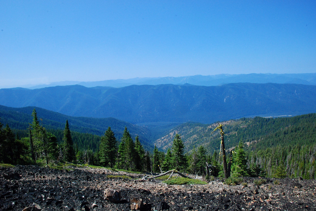
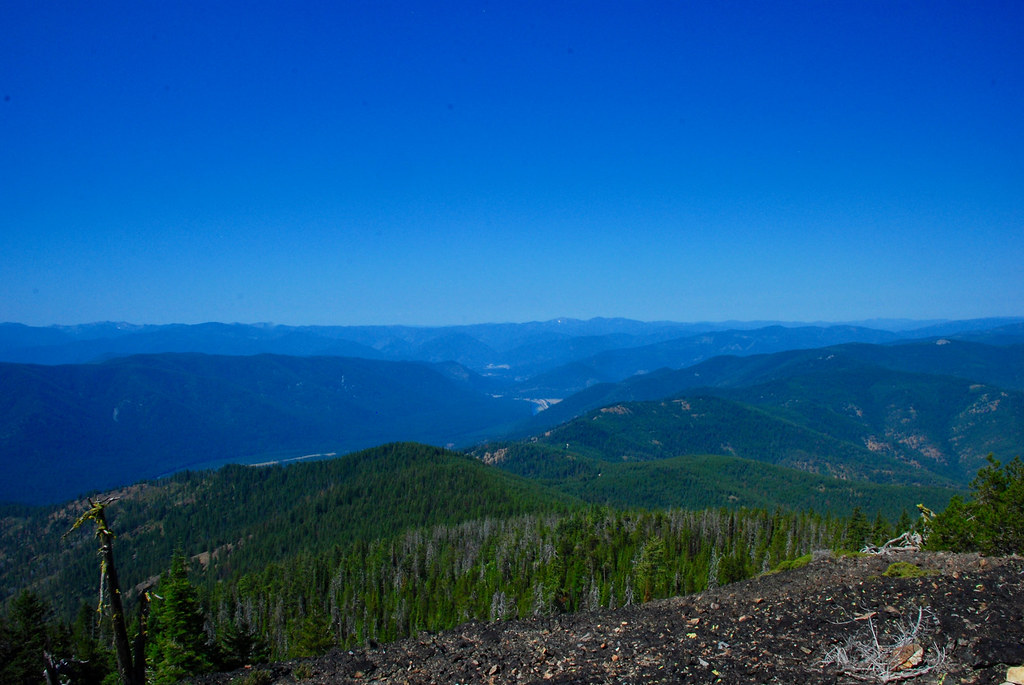
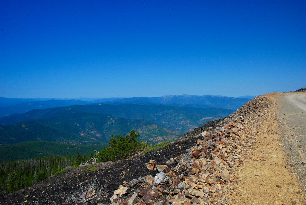
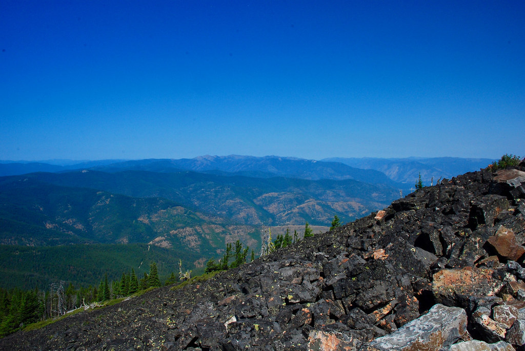
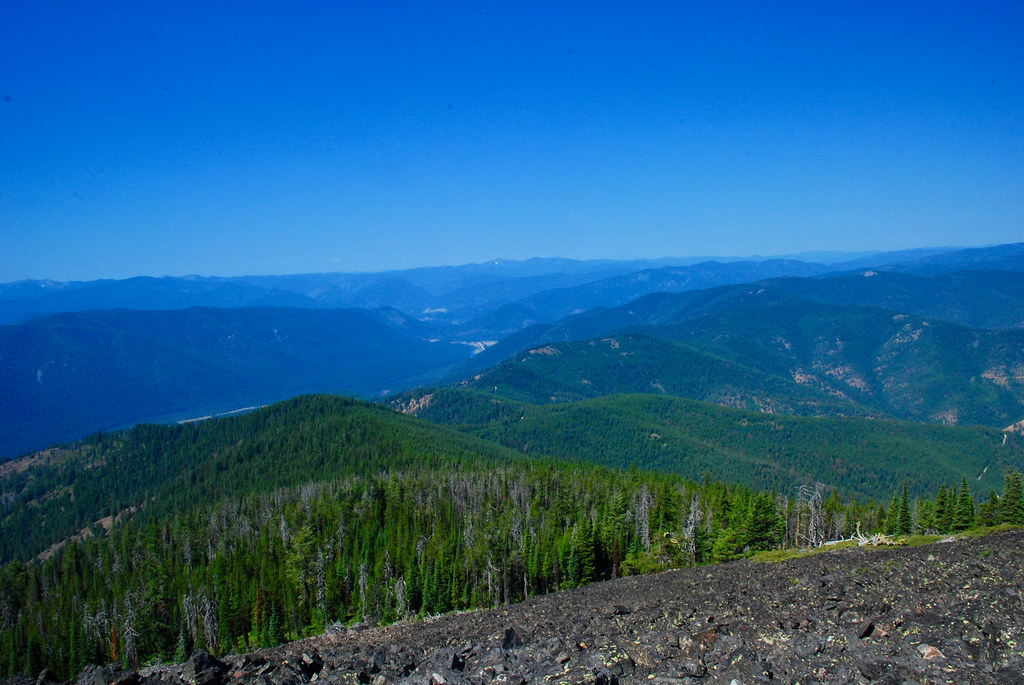
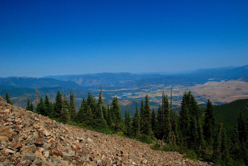
About 10 days ago I made a post about hiking the Donlan Saddle trail (USFS trail 205). On Thursday I drove to the top trail head of that trail and then on up to the fire lookout on top of the peak which is called Patrick’s Knob. Here are a few photos from just below the lookout, about 4,000 feet above the valleys around it:

….and what an extraordinary location to have a lookout!
You can see ‘forever’ is my immediate thought.
LikeLiked by 1 person
Comment by Vicki — July 22, 2017 @ 10:47 pm
This isn’t the highest lookout around, but it is in a very strategic location and has 360º views. One of my uncles manned that lookout for several summers in the 1930’s.
LikeLiked by 1 person
Comment by montucky — July 22, 2017 @ 11:08 pm
Beautiful views all around!
LikeLiked by 1 person
Comment by wordsfromanneli — July 23, 2017 @ 2:13 am
Yes. I like the 360º views.
LikeLiked by 1 person
Comment by montucky — July 23, 2017 @ 7:14 am
Great views. Very rare to come across!
LikeLiked by 1 person
Comment by nvsubbaraman — July 23, 2017 @ 2:20 am
Yes. There are few peaks her that have clear views in all directions.
LikeLike
Comment by montucky — July 23, 2017 @ 7:15 am
You can see about 150km on a good day, right?
LikeLiked by 1 person
Comment by paparadu — July 23, 2017 @ 6:45 am
The distance you can actually see is limited by the elevations of the next mountain range. To the south (in the second photo), the Bitterroot mountains are about 80km and they are higher, so that is the distance to the horizon in that direction. Roughly to the north (in the last photo), you can see much further looking just a little to the right of center. It is hazy in the photo, which is caused by the smoke from a complex of fires in that area that are 60 to 80km away. If the sky was clear in that direction, you could see 150km.
LikeLiked by 1 person
Comment by montucky — July 23, 2017 @ 7:27 am
Thank you for explaining. Helps to get a feeling for the area! 🙂
LikeLiked by 1 person
Comment by paparadu — July 23, 2017 @ 8:28 am
That was certainly a worthwhile climb. It looks like there’s a lot of charred wood up there though. Either that or the rocks are naturally dark. I hope you don’t see any more fires this year.
LikeLiked by 1 person
Comment by New Hampshire Garden Solutions — July 23, 2017 @ 2:04 pm
The black rocks are from desert varnish. It is common at the tops of rocky peaks where there is no break from the sun.
We have 20 fires burning in Montana right now, the largest is a complex of 5 fires with a total of 200,000 acres in the eastern part of the state. It is burning pine trees, dead and down trees, grass, and sagebrush: 0% contained. In the right-center of the last photo, the fuzzy area at the horizon is caused by smoke from a complex of about 4 fires about 30 miles north of my house. They are under control now. At the left at the skyline in the first photo you can see the smoke plume from a fire burning in the Bitterroot Mountains about 60 miles south of Pat’s Knob.
LikeLiked by 1 person
Comment by montucky — July 23, 2017 @ 4:03 pm
I hope they can get them under control if they’re near people.
LikeLiked by 1 person
Comment by New Hampshire Garden Solutions — July 23, 2017 @ 4:17 pm
So far there have not been any homes lost, but there are evacuations in several of the fire areas. There are so many fires burning across the west that resources have become scarce. We are getting help from Canada on some of the fires here.
LikeLiked by 1 person
Comment by montucky — July 23, 2017 @ 4:23 pm
I didn’t know it was that bad. I’m surprised there seems to be little about the fires on the news.
LikeLiked by 1 person
Comment by New Hampshire Garden Solutions — July 23, 2017 @ 5:29 pm
I guess because there hasn’t been a big threat to a lot of people or houses, the media doesn’t pay much attention to it.
LikeLiked by 1 person
Comment by montucky — July 23, 2017 @ 6:40 pm
Unless it’s Yosemite or Yellowstone. Then it’s big news.
LikeLiked by 1 person
Comment by New Hampshire Garden Solutions — July 23, 2017 @ 6:43 pm
Exactly.
LikeLiked by 1 person
Comment by montucky — July 23, 2017 @ 6:46 pm
Now that’s a view that stretches forever, and with very few signs of humanity – just the way I like it!
😉
LikeLiked by 1 person
Comment by de Wets Wild — July 23, 2017 @ 8:29 pm
Me too! Of the 50 states in the U.S., Montana is the 4th largest, but the 48th in population, with about 7 people per square mile. That leaves plenty of room for wilderness and wild forests.
LikeLiked by 1 person
Comment by montucky — July 23, 2017 @ 9:15 pm
And long may it stay that way!
LikeLiked by 1 person
Comment by de Wets Wild — July 24, 2017 @ 7:50 pm
Yes!
LikeLiked by 1 person
Comment by montucky — July 24, 2017 @ 9:21 pm
Wow, that is some height! What spectacular views. Exhilarating!
LikeLiked by 1 person
Comment by Jo Woolf — July 24, 2017 @ 1:55 pm
That’s why I love hiking the high trails!
LikeLike
Comment by montucky — July 24, 2017 @ 3:41 pm
What a fabulous vista .. and the sky is so blue! 🙂
LikeLiked by 1 person
Comment by Julie@frogpondfarm — July 26, 2017 @ 1:30 am
I’m glad that I went there when I did. We are now experiencing a multitude of fires and the sky is becoming very hazy from the smoke.
LikeLiked by 1 person
Comment by montucky — July 26, 2017 @ 7:17 am
Not good news on the fires …
LikeLiked by 1 person
Comment by Julie@frogpondfarm — July 26, 2017 @ 3:56 pm
The fire situation is bad this year and it’s just starting. On two of the fires, the fire management teams have said those fires won’t be out until there is either some heavy rain on the first snows of winter.
LikeLike
Comment by montucky — July 26, 2017 @ 4:05 pm
They can be so devastating .. for people and the wildlife. I hope you get heavy rain ..
LikeLiked by 1 person
Comment by Julie@frogpondfarm — July 27, 2017 @ 12:52 pm
I hope we do too!
LikeLiked by 1 person
Comment by montucky — July 27, 2017 @ 3:20 pm
I was stationed at Plains the summer of 1957, and after a Sunday movie was dispatched at 10:30 P.M. to hike up to Patrick Knob following a fire spotted by the lookout. I reached the lookout by 1:30 a.m. It was dead calm; the fire was smoldering in the top of a tree and not traveling, After a few hours rest, we hiked down and felled the tree. I remained there for two hours chopping out and
burying all ash and charcoal, thoroughly mixing it with cool mineral soil until no heat remained. Then, hiked back up to rejoin my partner at the lookout, and back down to the ranger station. Those were good days and great fellows to work with. I have worked
on three lookouts – -Jay Point(on the Powell District of the Clearwater-Nezperce N.F., Porphyry Peak and Monument Peak on the Lewis and Clark N.F. in the 1960’s and have been working as a volunteer on the Caribou-Targhee N.F. in eastern Idaho for the past eleven years and visiting campgrounds in connection with the Bear Aware program. Great memories to look back upon going on 90
years. I was nominated as President’s Volunteer of the Year in 2015 for the Inter-mountain Region. Still cross-country ski and snowshoe. It’s a great life if you don’t weaken.
LikeLike
Comment by Evan J. Tibbott — March 27, 2021 @ 1:34 pm